Geography as a Science. Geographic map - a special source of information about reality
Lecture 1
- Geography as a Science. Subject, object of geography
- Geographic research methods
- Sources of geographic information. Geographic map
- Great explorers of geographical discoveries
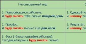
1. Geography is a science (more precisely, the system of natural and social sciences) that studies the functioning and evolution of the geographic envelope, the interaction and distribution of its individual parts and components in space - in order to scientifically substantiate the territorial organization of society, the distribution of population and production, the effective use of natural resources, conservation human habitat, creating the foundations of a strategy for environmentally safe sustainable development of society. The word "geography" comes from the Greek. ge - m - "earth" and "grapho" - I write.
Actually, geography as a science begins with "travel literature": getting into other, unfamiliar places, an intelligent observer recorded everything unusual for himself: what the people of this country look like, what they dress, what kind of political system they have, what plants and animals are in this country and much more. These were the rudiments of regional studies, when the country as a whole is described, "from geology to ideology," and it is precisely what is mentioned that distinguishes this country from all the others.
The famous Russian geographer Nikolai Baransky formulated this feature of science as follows: "What is everywhere (like air) should not be anywhere in geography." In other words, there is no need to write that in a given country there is air, soil, vegetation - it is everywhere; it is necessary to pay attention to how the air of this country (for example, its climate) is unique, how it differs from neighboring countries.
The most important subject of geographical study is the processes of interaction between man and nature, the patterns of placement and interaction of the components of the geographic environment and their combinations at the local, regional, nat. (state), continental, oceanic, global levels.
The task of geography is to reveal the specifics of the interaction of all these heterogeneous processes in each territory, to generalize the available materials and create a vivid, memorable image of the place - that is, to solve first the problem of describing the territory (and partially explaining the processes occurring on it).
The task of geographical forecasting is much more complicated: what future (or what options for the future) is possible for this territory. It is often necessary to confine oneself to identifying restrictions for development: for example, in such and such an area it is impossible to build enterprises even with small emissions of harmful substances, since their dispersion in the atmosphere is extremely slow; or: there is no need to create a recreation zone here (from the Latin "recreatio" - literally "restoration" of human strength and health), since it is far from the place of residence of potential vacationers.
The object of study of geography is the earth's surface with all its natural and social content.
The complexity of the object of research has led to the differentiation of a single geography into a number of specialized scientific disciplines, which gives reason to consider modern geography as a complex system of sciences, in which natural (physical and geographical), social (socio-geographical and economic-geographical) sciences, applied geographical sciences, etc. geographic sciences, which are integral (borderline) in nature. Physical geography includes complex sciences about the geographic envelope as a whole: geography (general physical geography), landscape science (regional physical geography), paleogeography (evolutionary geography). In the process of long-term development of geography, particular sciences were formed about the components of the geographic envelope - geomorphology, geocryology, climatology and meteorology, hydrology (with a subdivision into land hydrology, oceanology, limnology), glaciology, soil geography, biogeography.
Socio-economic geography includes general sciences: social geography and economic geography, as well as the geography of the world economy, regional socio-economic geography, and political geography. Private socio-geographical sciences: geography of industry, geography of agriculture, geography of transport, geography of population, geography of services. Integral geographic sciences include cartography, regional studies, and historical geography. The development of the system of geographical sciences has led to the formation of applied geographical sciences and areas - medical geography, recreational geography, military geography, etc. They also perform connecting functions between geography and other scientific disciplines. The desire to identify general geographic patterns in the development of all or many of the components of the geographic envelope, to model them led to the formation of a theoretical direction in geography.
Geography as a system of sciences was formed not by the convergence of isolated geographical sciences, but through the autonomous development of the once unified geography and its division into specialized scientific disciplines - according to components, their combinations, levels of research and the degree of generalization, goals and practical needs. Therefore, all private geographical sciences, no matter how far they diverged from each other, retained the general features of the geographical approach (territoriality, complexity, concreteness, globality) and the general specific language of science - the map.
2.
Geographic research methodology is a complex system that includes: general scientific approaches and methods (mathematical, historical, ecological, modeling, systemic, etc.); specific scientific approaches and methods (geochemical, geophysical, paleogeographic, technical and economic, economic and statistical, sociological, etc.); working techniques and operations for obtaining information (balance method; remote sensing methods, including aerospace; laboratory methods, e.g. spore-pollen analysis, radiocarbon method; questionnaires; sampling method, etc.); methods of empirical and theoretical generalization of information (indicative, evaluative, analogs, classifications, etc.); methods and techniques for storing and processing information (on electronic media, punched cards, etc.).
The special function of geography is the acquisition, generalization and dissemination of knowledge about our planet and the patterns of its natural-historical development, about countries, regions, cities, localities and peoples inhabiting them, about the history of the discovery and development of the world, about knowing it with the help of space means. Geographical discoveries have been an important aspect of universal human culture throughout the centuries, and they continue to this day.
3.
The following sources of geographic information are distinguished.
1. Geographic Information Systems (GIS). GIS is a computer-assisted "archives" of geographic knowledge about the territorial organization and interaction of society and nature. The GIS includes:
COMPUTER;
software;
spatial information in the form of cartographic data on natural components, economy, land, roads, etc.
GIS functioning is carried out in the following sequence:
collection and automated processing of geographic information;
spatial referencing of geographic information and its presentation in the form of an electronic map on the display screen;
translation of this map, if necessary, into paper form (for example, creating atlases).
An important component of GIS is aerospace information, aerovisual observation data, ground sensors, etc.
2. Geographical research:
field studies;
travels;
local history excursions
tourism, mountaineering.
Field research can be expeditionary and stationary. The expedition includes the study of individual natural components, branches of the economy, etc. Natural and economic complexes are learned in the process of comprehensive geographical research (natural-geographical, landscape, economic-geographical, etc.). Expeditionary research is divided into three periods:
preparatory;
field expeditionary;
office (processing of collected materials, writing a report, drawing up maps).
Aerospace images of the earth's surface are used during expeditionary research. They are decrypted, i.e. recognize objects reflected on them by their shape, color, image tone.
Artificial satellites provide an opportunity to study the dynamics and frequency of natural processes, unique phenomena and objects (volcanic eruptions, fires, avalanches, landslides, fractures of the earth's crust, atmospheric pollution, etc.).
3. Sources of geographic information are local history studies and descriptions of the native land, cities and other settlements. They also include descriptions of travel, tourist and mountaineering routes, excursions.
4. Maps and atlases are important sources of geographic information. Cartographic images reproduce the dimensions and properties of geographic objects using geographic means and signs (lines, shapes), as well as color tone. Combinations of geographic signs and background are means of cartographic modeling, creation of cartographic images (geo-images). To understand the natural and economic objects displayed on the map, components of natural conditions, processes, as well as the patterns of their distribution, legends are attached to the maps. Legend text, geographical names, terms and concepts allow you to “read” the map and use it.
Maps are the most important components of information building blocks of geographic atlases.
5. Diverse geographical information is stored by regional, district, city museums of local lore.
6. Various geographic information is available in textbooks, manuals, statistical reference books, dictionaries, encyclopedias, scientific journals, periodicals. The media are filled with geographic information: newspapers, radio and television programs. Geographic popular science, documentaries, educational films are being created. Geographic information can be found in fiction, paintings, landscape architecture, etc. Great opportunities for obtaining and using relevant geographic information are provided by the Internet.
Map - a reduced generalized conventional symbolic image of the Earth's surface (its part), other planets or the celestial sphere, built in scale and projection (i.e., according to the mathematical law).
Geographic map - an image of the earth's surface model, containing a coordinate grid with conventional signs on a plane in a reduced form.
Maps with a common design can be combined into an atlas.
2. What source of geographic information is of particular interest to you? Why?
Geographic maps are of particular interest. As a source of geographic information, they are unique. With the help of geographic maps, you can compile a sufficient detailed description of any territory on the Earth. They provide insight into the location of geographic features and the distribution of geographic phenomena. Thus, geographic maps are the main source of geographic information.
3. Analyze a newspaper or magazine. Write down the terms, names, related, in your opinion, to the course of geography that you are going to study.
In newspapers and magazines, the following terms are most often found that can be attributed to the course of geography: country, state, territory, border, population, weather, military conflicts, transport, city, industry.
4. Continue definition
Cartographic projections are called mathematical methods of displaying on the plane of the earth's surface (ellipsoid).
5. Why do map projections display the earth's surface in a distorted form?
Map projections are plane images of the earth's surface. It is impossible to transfer a spherical surface to a plane without distortion.
6. Complete the diagram

7. What determines the choice of a map projection
The choice of a cartographic projection depends on the purpose of the map, the size of the depicted area and the latitude at which it is located.
8. Give examples of using specific cartographic projections for the image: a) polar regions; b) the territory of Russia; c) continents and oceans; d) the world. To do this, use the text §3 in the tutorial.
A) polar regions - azimuthal projection;
b) the territory of Russia - conical projection;
c) continents and oceans - conical or cylindrical projection;
d) the world is a cylindrical projection.

The photograph shows a modern city. The perspective of photography speaks of its considerable size. Of the characteristic features, the predominance of medium-rise buildings can be noted. High-rise buildings are typical only for a business center. The spiraling, swirling tower shown here is a feature of modern large cities in developed countries. The sparse vegetation among the sands indicates a dry climate.
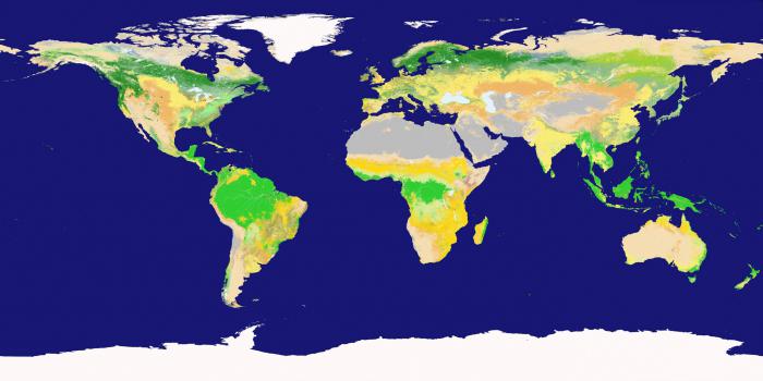
10. Carefully study Figure 3 in the textbook. Select any map in the atlas for grade 7 and indicate which depiction methods were used to create it.
Physical map of the world - quality background, linear signs, off-scale signs.
11. Analyze the maps in the atlas, select from them:
a) general geographic - physical map of the world, physical maps of continents;
b) thematic - a map of the structure of the earth's crust, geological maps, climatic maps of the world and continents, soil maps, maps of natural zones, political maps, maps of population and peoples density.
How do the maps in the atlas differ in scale?
The atlas contains small-scale and medium-scale maps.
13. A cartographic projection is:
1. drawing of any territory;
3.degree grid
2. mathematical methods of image on the plane of the earth's surface;
14. Choose the correct statement:
1. Map projections display the earth's surface without distortion.
3. A cylindrical projection is used to display the polar regions.
2. Linear signs on the map show roads, rivers, borders.
15. Territories that are homogeneous in some way are distinguished;
1. isolines;
2. linear signs;
3. in the way of high-quality background;
4. off-scale signs.
3. in the way of high-quality background.
A geographic map is a reduced generalized image of the earth's surface, showing the location, state and connections of various natural and social phenomena, their changes in time, development and movement in accordance with the purpose of this map.
It is natural to consider geographic maps as visual figurative-symbolic models. They are characterized by the main features of models in general: abstraction from the whole for the study of a part - a specific territory, specific phenomena and processes; simplification, consisting in the refusal to take into account the many characteristics and relationships and in preserving some of the most essential; generalization, meaning the allocation of common features and properties, etc. These abstractions contribute to a deeper understanding of the phenomena depicted on the maps.
The first feature of geographic maps is the construction with the help of cartographic projections, which allow obtaining correct data on the position, planned dimensions and shape of the terrestrial objects depicted on the maps.
The second feature of geographical maps - the use of cartographic signs as a special map language - makes it possible to:
a) depict the earth's surface with a desired decrease (i.e., at a desired scale) in order to cover with a single glance the necessary part or even the entire earth's surface, while reproducing on the map those objects that, due to the decrease, are not expressed on the scale of the map, but in their own way the value should be shown;
b) show the relief of the earth's surface on the map (for example, using contours), that is, transfer the unevenness of the terrain in a flat image;
c) not be limited to displaying the surface of objects on a geographic map, but indicate their internal properties (for example, on a sea map, you can show the physicochemical properties of water, currents, relief and soils of the seabed, etc.);
d) show the spread of phenomena that are not directly perceived by our senses (for example, magnetic declination, gravity anomalies, etc.), and make clear connections and relationships inaccessible to direct perception (for example, between sources of raw materials and enterprises for its processing);
e) exclude less significant aspects, particulars and details inherent in single objects, and highlight their general and essential features (for example, characterize settlements in terms of population and administrative significance, refusing to transfer their layout), that is, resort to abstraction.
The third feature of geographical maps is especially important - the selection and generalization of the phenomena depicted, that is, cartographic generalization.
Geographic maps have been and remain the main source of geographic information. Maps allow a one-time view of space in any range - from a small area of \u200b\u200bterrain to the surface of the Earth as a whole. They create a visual overview of the shape, size and relative position of objects, allow you to find their spatial dimensions: coordinates, lengths, areas, heights and volumes. Maps contain the necessary quantitative and qualitative characteristics of these objects and, finally, show the existing connections between them: spatial and some others. These properties explain the meaning and value of the cards for practice.
Geographic maps, fixing the position, state and spatial relationships of specific objects (phenomena), allow not only to economically and expressively present knowledge about the location of phenomena, but also to find the patterns of this location. In some branches of knowledge, maps are used as the main research tool.
Maps serve as a reliable guide on land and in the ocean, when moving troops and on hiking trips, for flying in an airship and for a walking route.
In military affairs, they are the main source of information about the terrain and an obligatory tool for command and control of troops and the organization of their interaction.
In industrial, energy and transport construction, maps are used as a basis for surveying, designing and transferring to nature an engineering project. Now the most profitable routes of railways, highways and pipelines are not being sought out in the field, but are outlined using topographic maps in the offices of design organizations.
Maps are widely used in agriculture for land management, land reclamation, measures to improve soil fertility, to combat erosion and, in general, to record and the most correct, efficient use of all land funds.
The cards make up an indispensable tool for school and extracurricular learning. They are not only a repository of accumulated geographical knowledge, but also an effective means for their dissemination, the rise of a common culture. Without exaggeration, it is fashionable to say that cards are used to one degree or another in all spheres of human activity.
Maps have acquired great importance as a means of scientific research, especially geographical. Each geographical study, in one way or another, proceeds from existing maps, provides materials for their implementation and improvement. The scope of using maps as a means of scientific research is rapidly expanding with the general increase in the pace of scientific progress. In particular, this expansion is facilitated by advances in the development of computer science and in the development of modeling theory.
The study of general problems of collecting, storing and transferring knowledge by computer science makes it possible to more fully appreciate the advantages of geographical maps as a special form of processing, presentation and analysis of spatial information. As noted, these advantages lie in the possibility of a one-time, holistic perception of cartographic images, in the visibility of territorial differences and in the convenience of analyzing spatial combinations, interrelationships and patterns.
Modeling method in geography, geoinformation and distance methods are based on the cartographic method. The energetic introduction of modeling methods into modern science has opened, when applied to cartography, the real power of maps as generalized and simplified spatial images of the real world, that is, its models reflecting those aspects, properties and processes of reality that are important for the purposes of specific research. Maps allow you to gain new knowledge, study development processes and predict many phenomena. The development of methods for using maps as a research tool is one of the main tasks of modern cartography.
Despite the introduction of new methods into geography, the cartographic method is one of the main in research. And although now maps are often stored in computer memory and are part of geographic information systems that receive information from satellites and from numerous weather stations, including databanks containing reports on the results of the work of many research teams, the map remains the most perfect way of transmitting spatial information.
For a long time, a person was interested in what is located beyond the horizon - new territories or the end of the earth. Centuries passed, civilization accumulated knowledge. The time has come when scientists, who have never been to distant lands, knew a lot about them. In this they were assisted by sources of geographic information.
This article will tell you about what it is, as well as about their varieties.
General concepts
As you might guess, this is the name of all of which a person can get information of interest to him. What sources of geographic information are considered by the 5th grade (in secondary school)? Let's list them:
- All geographical maps, atlases, as well as various topographic plans, including military ones.
- Diverse geographic descriptions of a specific area.
- Reference books, encyclopedic articles, results and reports of various expeditions.
- Aerial and space
- and GPS / GLONASS.
These are the sources of geographic information in the 5th grade in the average general education school. We will try to consider the characteristics of some of them in a little more detail.
Modern technologies
In recent years, more and more sources have been converted from paper to digital form. And this is not surprising. Almost all 5 sources of geographic information that we just talked about today can be found in digital form. Even professional scientists in recent years have preferred to work with digital.

The same GIS system is much more convenient to work with than a pile of books. Now let's discuss some sources of geographic information in more detail.
Cards
A map is a schematic generalized image of the surface of a piece of the earth, the entire planet or celestial bodies. It is built on the principle of scaling, that is, mathematical methods are used for this. It is depending on the scale that all maps are usually divided into three large groups:
- Large-scale.
- Medium Scale.
- Small-scale.
If we talk about the first category, then these documents may have a ratio of 1: 200,000 and larger. This includes almost all topographic plans. Small-scale maps are considered all maps with a ratio of less than 1: 1,000,000. A typical geographic atlas includes either small-scale or medium-scale maps that are best suited for the study of a particular area.
Sorting cartographic information
You should know that even long before the creation of the map, specialists make a strict selection of what will be depicted on it. This process is called as follows: cartographic generalization. Naturally, the most stringent selection exists in relation to small-scale maps, since they need to accommodate the maximum amount of useful information with the minimum occupied area of \u200b\u200bthe document. In the generalization itself, the direct purpose of the card, as well as the wishes of its customer, plays an extremely important role.
Site plans

This is the name of the terrain drawings, which are carried out on a large scale (1: 5000 and more), and they are drawn using special symbols. In this they resemble a school geographic atlas. The construction of such plans is carried out on the basis of eye, instrumental measurements, aerial photography, or a combined method.
Since the plans indicate relatively small areas of the earth's surface, when creating them, the curvature of the planet can be neglected. It should be clearly understood that these sources of geographic information that we have just described are radically different from each other.
The main differences between plans and maps
- In a centimeter of the plan, more than five real kilometers on the ground are rarely laid. They are much more detailed than maps, in one millimeter of which hundreds of kilometers of the earth's surface can be laid.
- All objects on the ground in the plans are depicted in maximum detail. In principle, all more or less significant areas are marked on the average drawing. So, on the topographic plans of the General Staff of the Armed Forces of the Russian Federation (and the USSR, of course), even trees and small streams can be displayed. It is impossible to fit all this information onto maps. Actually, that's why the generalization, which we talked about above, is being carried out. Even the exact outlines of continents cannot be displayed on many maps, and therefore they are often plotted with significant distortion. In addition, the geography supplementary literature described above uses off-scale conventions.
- We emphasize once again that when constructing a plan, the curvature of the earth's surface is neglected. Maps, especially on a small scale, take it into account without fail.
- There is never a degree grid on the plans. At the same time, there are parallels and meridians on each of them.
- The plan is always easy to navigate. The top of the document is north, the bottom, respectively, is south. On maps, the direction is determined by the parallels.
Ways of depicting objects on plans and on maps

Conventional signs in this case are generally accepted options in which the characteristic of objects depicted on a map or plan is encoded. With their help, you can display both something concrete (a mountain, for example), and something completely abstract, conditional (population density in a city, village, etc.). Of course, they all make life much easier for a person who knows the basics of cartography and can read these drawings.
How long does the card remain valid?
Almost all geographers and geologists ask this question at least once in a while. The specific answer to it depends on the purpose, scale, and author of the plan. Thus, medieval researchers often drew maps literally on their knees, so there is no need to talk about their accuracy. But the maps of the General Staff, despite the time, are still striking in their accuracy.
Do not forget that the cards are quite stable, while the plans of the Amazon and the Nile can be safely thrown away fifty years after their publication. These rivers so effectively and quickly change the relief of the Earth's surface that there is only sense from older documents in a historical perspective.
Geographical descriptions, discoveries
All the sources of geographic information discussed above are somewhat dry and uninteresting. It is much more exciting to read the description of a region, locality or even the mainland, written by the person who discovered all this!
All jokes, but descriptions and reports on geographical (geodetic, biological) research can sometimes give much more information than the most detailed topographic plan of the area. Moreover, the latter does not reflect some unpleasant features of a particular area (malaria, which occurs in some central regions of Africa at every step, for example).
The list of geography literature that students are given at school (for example, Nikolina V.V. Geography, Lesson development; Samkova V.A.We study the forest; Forest encyclopedia: in 2 volumes / chief editor G.I. Vorobiev ), just the same, and was formed thanks to the works of researchers, who at one time entered all this information on the map, being in the thick of things.
Brief information about the discovery of Africa
Let's tell a little about the history of the discovery of the Black Continent. Of course, the word “discovery” is not entirely correct here: here is Australia - yes, I had to suffer with it. In the case of Africa, the coastal regions were perfectly explored, where they caught black slaves and bought ivory from Arab traders, but almost no one knew about what was happening in the interior of the continent.
Everything changed in the 19th century, when the legendary arrived in Africa It was to him that the honor of discovering the sources of the Nile and the magnificent Lake Victoria belongs. Few people know, but the Russian scientist V.V. Yunker (in 1876-1886) was engaged in the research of Central Africa at one time.
For the indigenous population of the mainland, all this ended sadly: the main sources of geographic information (that is, maps), data for which all these brave scientists were collecting with such difficulty and constant danger to life, began to be actively used by slave traders ...
So, with maps and plans, we are actually finished. Geographic atlases fall into the same category. What is the role of modern sources of geographic information? To answer this question, let us consider the principle of sharing old paper maps and a navigator, which even professional geographers and geologists are now actively using.
GPS / GLONASS + maps

It should be noted that this method is excellent for determining the accuracy of maps, atlases and topographic plans. In addition, this technique meets the needs of historians, since they can personally see how much the area has changed, which is described in historical chronicles by contemporaries of certain events. However, the literature on geography often contains site plans that have not been updated since the beginning of the last century.
To use such an accurate, but rather laborious and somewhat extravagant method, you will have to perform a threefold binding (three different maps) to the same area of \u200b\u200bthe terrain:
- First, find a more or less modern map or topographic plan.
- It is advisable to have a fresh aerospace image of the surveyed area with a topographic reference to the coordinate system.
- Finally, you need the card whose information you are going to check.
The point of this operation is to enter all three of these terrain drawings into the navigator's memory. Modern models of such devices have a powerful enough processor and an impressive amount of RAM, so you can switch between cards instantly.
Determination of the route
Route planning is best done using a modern map or topographic plan. We do not recommend using old documents for this. It is quite possible that on the site of the swamp there is now passable terrain, but you will not be able to walk along the edge of the once rare young forest, since the geography of the area has radically changed. A map is good, but in most cases such documents are not very accurate.
Why aerial photography and satellite imagery are preferable to maps?
But why are paper drawings so inferior to products of modern technology? There are two reasons for this:
- Firstly, the relevance of space photography or aerial photography is much higher in most cases. When else will cartographers be honored to carry out the next generalization of new data and release up-to-date plans of the area?
- In the pictures, you can literally determine in real time the characteristics of a particular area. On a map or even a topographic plan, tree species in the forest will be displayed only schematically and only in general order. Simply put, it is quite possible to stumble upon a dense spruce forest in the middle of a birch forest, but in a dense coniferous forest it is much easier to get lost.
After choosing a route and checking the new images, it is recommended to refer to the old map. Why are such difficulties? Imagine you are a field biologist. You need to determine how much the forest has grown, what new tree species have appeared, how many types of forest have changed over the years. Ideal for all these tasks is a simple overlay of a new card on its old counterpart. Thus, everything becomes visible as clearly as possible.

Here are the sources geography uses. The map is perhaps the most important of them, but one should not forget that over the past decades, science and technology have made a huge step forward, and therefore it is foolish not to take advantage of all modern achievements.
Conclusion
So you have learned which sources of geographic information are currently the most relevant. Oddly enough, but we still use all the same plans and maps that were invented before our era. Of course, adjusted for their modern look.
Lesson number 1
Topic: Introduction. Sources of geographic information.
Study Questions
1. Economic and social geography as a science.
2. Traditional and new methods of geographical research.
3. Types of geographic information, its role and use in people's lives.
5. Geographic map is a special source of information about reality. Statistical materials. Other ways and forms of obtaining geographic information: the use of satellite images, modeling.
1. Economic and social geography as a science, its place in the system of geographical sciences.
Geography is one of the oldest sciences on Earth and occupies an honorable place among the favorite school disciplines. The course of economic and social geography of the world is the final stage in the study of geography in the school curriculum. The subject of the study of economic and social geography is the study economic development and population distribution in the world as a whole, in certain regions and countries. Economic geography combines elements of geography, economics and sociology; it widely uses not only economic, but also sociological research methods. You know that sociology is the science of society and human behavior, and economic and social inequality are closely related, so you cannot consider an economy without people - the main productive force, without the human factor. Thus, by putting the human being in the spotlight, economic geography became related to social geography. The main direction of the current stage of development is the strengthening of the social, political, environmental focus of research. The main direction is the rational use and transformation of the natural environment. Long-term development of geography has led to the deepening of its internal differentiation. In economic geography: the geography of the population, agricultural industry, transport, services and services. Nowadays, geography from a descriptive and cognitive science has turned into a science of a constructive nature.
Various methods of geographical research are known in modern geography. The most popular are traditional geographical research methods:
I. Traditional methods -
a) descriptive -the study and description of any territory is carried out according to a certain plan. The description can be either single-element (when only one component is considered, for example, the hydrological network, relief, landscapes), and complex (when the entire territorial complex is considered: nature - population - economy).
b) comparative - Comparative analysis is often used in the study of various territories and geographical objects. Objects of study can be located close to each other (for example, the coast of the Black and Azov Seas) or be removed (for example, mountain systems of the Cenozoic folding regions of South America and Europe) and similar features are analyzed. As a result, elements of similarity and differences are highlighted and appropriate conclusions are drawn.
c) cartographic - for the study area, special maps or series of thematic maps are created in order to understand any phenomenon. With the help of predetermined conventional symbols, certain elements of the territory under consideration (relief, climate elements, landscapes, etc.) are applied to the cartographic base. The cartographic method is usually used with other research methods: interpretation of aerial photographs, mathematical, etc.
d) retrospective (historical approach). The study of any geographical object, territory: its landscapes, its individual components, natural and social phenomena - is considered in time, which allows us to make a forecast for the future.
e) typological - According to the selected criteria, reference sites (key) in the study area are allocated in order to further disseminate the findings to other areas.
II.Modern methods of geographical research:
a) Geographic forecast - foreseeing the future state of geosystems. b) Geoinformatics. We live in an era of "information explosion", when the volume of scientific knowledge and the number of sources of information are growing very quickly. Informatics makes it possible to apply economic and mathematical modeling. The development of geoinformatics has led to the creation GeoInformation Systems (GIS). GIS is an information system that provides collection, storage, processing, analysis and display of spatial data and associated nonspatial data, as well as obtaining information and knowledge about geographic space on their basis.
It is believed that geographic or spatial data constitutes more than half of all circulating information used by organizations engaged in various activities in which it is necessary to take into account the spatial distribution of objects. GIS is focused on ensuring the possibility of making optimal management decisions based on the analysis of spatial data.
The introduction of GIS technologies in geography has affected many industries, primarily pictography. (Example: world electronic maps have already been created, differing in nature and language. National electronic atlases: USA, Canada, Japan, Sweden, China, etc.)
c) Space research methods our planet, these are climatic and space resources - the resources of the future.
Types of geographic information
Geographic information (GI) includes any information related to objects, phenomena and processes localized in a geographic space. A significant proportion of geographic information is found in sources that are not maps. Examples of this are addresses in phone books, road kilometer markers in incident reports, place names in a gazetteer, Internet portals. The completeness of the information presented in cartographic works is determined by the totality of map sheets with relatively simple topics - thematic cartographic layers tied to one base map. There is a special system of geographic symbols to represent various objects. Let's consider the most used ones:
Linear signs - borders, roads, rivers, etc. ... Isolines - connection of points with the same parameters (isobars - atmospheric pressure, isotherms t 0 of air) Areals - Areas of occurrence of certain phenomena. Traffic signs - these are traffic flows, sea currents, winds, etc. Quality background - used to display national and religious composition (without quantitative indicators) Cartogram - different intensity of phenomena within territorial units. Cartodiagram - a map with a certain territorial division and diagrammatic figures corresponding to these divisions. Map-scheme - a schematic map that does not have an accurate basis (route map for travel, etc.) Data for mapping is currently obtained via satellites. Thus, there is a real opportunity to present geographic information of any volume and complexity, and the role of the GI for the life of people is enormous. This is the most accurate and prompt receipt of information about the weather forecast, the degree of development of various emergency events, as well as obtaining special information, for example, the thickness of the snow cover (this is important for agriculture), the degree of coverage of cereal crops by insect pests, the degree of aridity of the region, the degree of deforestation plantings, etc.
Sources of geographic information.
1. Maps, atlases, topographic plans.
2. Geographical descriptions of different territories.
3. Encyclopedias, reference books, statistical materials, etc.
4. Space and aerial photographs.
5. Geographic information systems (GIS). At present, all the listed sources of information can be digitized and transferred from paper to electronic form, an example of GIS.
A geographic map is a special source of information about reality.
General geographicmaps display various elements of the earth's surface - relief, vegetation, rivers, settlements, transport networks, etc.
Thematicmaps characterize geographic objects and phenomena on a specific topic: vegetation, relief, industry.
For example, a political map will first of all give an idea of \u200b\u200bthe location of countries, their borders, etc.
Home assignment:
1. Show on a contour map parts of the world and continents.
2. Indicate the role of economic and social geography as a science, its place in the system of geographical sciences.
3. Determine the types of geographic information, its role and use in people's lives.
4. Geographic information systems as a means of obtaining, processing and presenting spatially coordinated geographic data.
5. Study the geographic map as a special source of information about reality and statistics. Explore the features of the legend (legend) on the political map of the world. Indicate other ways and forms of obtaining geographic information: the use of satellite images, modeling.
Independent work
Lesson number 2 A political map of the World
Study Questions
1.Countries on the modern political map of the world. Their grouping by area, population, elements of the political map of the world.
2. Quantitative and qualitative changes on the world map.
3. The main periods of the formation of the political map of the world.
4. Typology of the countries of the world. Political system. Forms of government.
The political map of the world is a geographical map that reflects countrythe world , andform of government andstate structure . The political map of the world reflects the main political and geographical changes: the formation of new independent states, a change in their status, the merger and division of states, the loss or acquisition of sovereignty, a change in the area of \u200b\u200bstates, the replacement of their capitals, a change in the name of states and capitals, a change in the forms of government and the form of state devices. The political map of the world has characteristic elements by which it can be determined, this is
State borders
State territories
Territories with international regime
Mixed territories
Sovereign states
Non-Self-Governing Territories
Forms of government
What is customary to designate in the economic geography of the world by the terms: State, Country, Territory? The concept of the state means, first of all, the political system of power established in a certain territory, while the concept of a country rather refers to cultural, general geographic (common territory) and other factors. The concept of a country is less formal than that of a state. Territory or trust Territories - dependent territories included as a result of the Second World War in the UN International Trusteeship System. These are mainly colonies of Germany and its allies in Africa (Cameroon, Rwanda, Burundi, Somalia, Tanzania, Southwest Africa) and islands in the Pacific Ocean (Western Samoa, Nauru, New Guinea, Mariana, Marshall and Carolina) with a population about 20 million people. They were managed by the former colonial powers - Great Britain, Belgium, France - by agreement with the UN and under the control of its Trusteeship Council. By 1997, almost all territories had become independent states. Before modern states were formed on the planet, there was a long period of formation of the political map of the world.
The main periods of the formation of the political map of the world
1. Ancient period (up to the 5th century AD)
2. Medieval period (V-XV centuries)
3. New period (the turn of the XV-XVI centuries - 1914)
4. The newest period (from 1914 to the present)
First stage (from 1914 to 1945)
Second stage (1945-1990)
Third stage (from 1990 to the present)
According to various sources (November 2015), there are 230 territories in the world, including:
193 independent states (recognized by the UN)
14 unrecognized states
3 territories with undefined status
1 quasi-state formation Order of Malta - has observer status at the UN.)
62 dependent territories
The process of birth and disappearance of states is endless, this process is called changes on the political map of the world. Changes on the political map are quantitative (accession of newly discovered lands to the state, territorial gains and losses after wars, unification or disintegration of states, exchange of land plots by states, etc.) and quality(the acquisition of sovereignty, a change in the form of government and state structure, the formation of interstate unions, etc.). At present, quantitative changes are decreasing, and mainly qualitative changes are taking place on the political map of the world.
Currently, taking into account the level and nature of socio-economic and political development, they distinguish the following groups of countries in the world:
Countries of the world are grouped according to different criteria
... For example, sovereign, independent countries and dependent countries and territories are distinguished. Dependent countries and territories can have different names: possessions - the term "colonies" has not been used since 1971 (there are very few of them), overseas departments and territories, self-governing territories. Thus, Gibraltar is a British possession; the country of Guiana in South America is a department of France; the island country of Puerto Rico has been declared a "freely acceding state to the United States."
Grouping of countries by territory size:
VERY LARGE COUNTRIES: (territory of more than 3 million sq. km): Russia (17.1 million sq. km), Canada (10 million sq. km), China (9.6 million sq. km), USA (9.4 million sq. km), Brazil (8.5 million sq. km), Australia (7.7 million sq. km), India (3.3 million sq. km)
MICROSTATE: Andorra, Liechtenstein, Monaco, San Marino, Vatican. These also include Singapore and the island states of the Caribbean and Oceania.
COUNTRIES BY POPULATION:
In terms of population, the 10 largest countries of the world are distinguished: China (1318 million people), India (1132 million people), USA (302 million people), Indonesia (232 million people), Brazil (189 million people). people), Pakistan (169 million people), Bangladesh (149 million people), Russia (146 million people from the Crimea River Nigeria (144 million people), Japan (128 million people) (data for 2014-2015)
THE SMALLEST IN POPULATION IN THE COUNTRY - microstates. The Vatican, for example, has a population of 1,000.
ECONOMICALLY HIGHLY DEVELOPED STATESAND are distinguished by a mature level of development of market relations. Their role is great in world politics and economy; they have a powerful scientific and technical potential. They differ from each other in the scale and level of economic development, in the size of the population. USA, UK, Japan, etc.
POOR COUNTRIES - Basically the former colonies, which, having gained political independence, fell into economic dependence on their former metropolises. These are most of the countries of sub-Saharan Africa, countries such as Angola, Ghana, Zambia, as well as the Asian countries of Afghanistan, Bangladesh, etc. They are very far behind the developed world in all major socio-economic indicators. (see the list at the end of the topic)
State forms of government.
The form of government characterizes the organization of government, the system of higher government bodies. There are two forms of government: republican and monarchist – a form of government in which the highest legislative power belongs to an elected representative body of parliament, and executive power belongs to the government. Republics are subdivided into parliamentary and presidential. IN presidential republics, the president is endowed with very large rights, he himself heads the government. (USA, Iran, Argentina, etc.) IN parliamentary the main figure is the head of government. (Germany, Italy, Israel, etc.) Monarchical form of government - the power under which the head of state is the monarch. This supreme power is inherited. Monarchies are subdivided into absolute, constitutional, theocratic .
Absolute monarchy - the power of the monarch is practically not limited (Bhutan, Oman, UAE, Qatar, Bahrain, Kuwait, etc.)
Theocratic monarchy - the monarch simultaneously represents secular and spiritual power. (Vatican, Saudi Arabia, Bahrain).
A constitutional monarchy - the power of the monarch is limited to parliament. On the modern political map, 30 countries of the world have a monarchical form of government.
Forms of administrative-territorial structure
Countries are subdivided to unitary (under which there is a single legislative and executive branch in the country ). Federated - in which, along with uniform laws, there are separate self-governing territorial units with their own legislative, executive and judicial authorities.
Home assignment:
1. Give a brief description of the state (of your choice in free form).
2. Using reference materials, maps, fill in the table, marking the countries
the world with a federal administrative-territorial structure. Explain what
is the difference between unitary and federal forms of administrative
territorial structure.
Lesson number 3
Topic: Typology of the countries of the world. Political system. Forms of government.
Study Questions
1.Differences of the countries of the modern world in terms of territory size, population size, population characteristics, peculiarities of geographical location.
2.Types of countries. Economically developed and developing countries (main; highly developed countries of Western Europe; countries of the resettlement type; key countries; countries of external development; new industrial countries and other groups).
3. UN and its main structural units
The political map of the world is represented by individual countries and regions. For a complete study of the country, it is customary to consider it from different points of view: according to the size of the territory, geographical location, the nature of the social system, the level of socio-economic development, historical and geographical regions, etc. GDP is used to rank countries by socio-economic development. Gross Domestic Product is one of the great inventions of the 20th century, almost equal in value to the automobile. GDP is the sum of all benefits produced in the territory of a given country for a year, and GROSS NATIONAL PRODUCT (GNP) is the volume of benefits produced according to the national principle: GDP minus profits of foreign companies transferred abroad and wages of foreign workers, plus similar receipts from abroad. Countries around the world use different methods of calculating GDP and GNP, so the data provided by national statistics and international ones are almost always different.In order to ensure the possibility of cross-country comparisons, in international statistics data on GDP is given in a single monetary measurement - US dollars. They are calculated by UN experts using special methods - at official exchange rates or at purchasing power parities. Therefore, these data, depending on the calculation method, differ significantly from each other.
There is a classification adopted by the UN - the division of the countries of the world into "industrialized", "developing" and countries with a "centralized planned economy".But at the same time, this division unites extremely different countries into one group. It is obvious that such countries as, for example, the United States and Switzerland, classified as "economically developed countries", or Kuwait and Papua New Guinea (included in the developing group) have, of course, common features, but even more differences between them. The group of industrialized countries includes about 30 countries. They are distinguished by a high level of economic development, the predominance of manufacturing and service industries in GDP, high quality and standard of living of the population. These countries create the bulk of the world's industrial production. They account for more than 70% of the world foreign trade turnover, including about 90% of exports of machinery and equipment.
Economically developed countries include about 60 countries in Europe, Asia, North America, Australia and Oceania. All of them are characterized by a higher level of economic and social development and, accordingly, GDP per capita. However, this group of countries is characterized by a rather significant internal heterogeneity and four subgroups can be distinguished in its composition.
G7 countries "Big Seven" (GDP per capita 20-30 thousand dollars) - Japan, USA, Germany, France, Great Britain, Italy, Canada.
Privileged highly developed countries of Western Europe: Belgium, Switzerland, Austria, Sweden, Norway, etc.
Countries of "resettlement" capitalism: Canada, Australia, New Zealand, South Africa, Israel.
Countries Nafta USA, Canada, Mexico.
"IMF" among the developed countries includes Western Europe, including the EU. The unification of the EU causes a lot of controversy, the second and third wave of countries that joined the EU gives rise to many doubts. Simply put, all countries in the European Union, although they are independent, are subject to the same rules: they have the same rules for education, medical care, pension, judicial systems, etc. In short, the laws of the European Union are valid in all countries of the European Union.
For 2013:, there are 28 countries in the European Union.
- Austria (1995)
- Belgium (1957)
- Bulgaria (2007)
- UK (1973)
- Hungary (2004)
- Germany (1957)
- Greece (1981)
- Denmark (1973)
- Ireland (1973)
- Spain (1986)
- Italy (1957)
- Cyprus (2004)
- Latvia (2004)
- Lithuania (2004)
- Luxembourg (1957)
- Malta (2004)
- Netherlands (1957)
- Poland (2004)
- Slovakia (2004)
- Slovenia (2004)
- Portugal (1986)
- Romania (2007)
- Finland (1995)
- France (1957)
- Croatia (2013)
- Czech Republic (2004)
- Sweden (1995)
- Estonia (2004)
Iceland candidates
- Macedonia
- Serbia
- Turkey
- Montenegro
All of them are members of the Organization for Economic Cooperation and Development (OECD).
The developing country group includes the largest number of states in the world (about 150). These countries are extremely different - this group includes Brazil and Tuvalu, India and South Korea, Somalia and Burkina Faso, etc. However, they all share such common features of socio-economic development as: the colonial past, which predetermined the territorial structure and predominantly agrarian raw material specialization of the economy.
Features of participation in the international division of labor; unequal position in the world economy, dependence on foreign capital; huge external debt; the presence of acute problems - demographic, environmental and food, as well as the low standard of living of most of the population, and others. Nevertheless, among the developing countries there are countries and territories that, in terms of socio-economic development, have already approached the level of industrialized ones. Let's take a closer look at large economic associations:
1. Countries with economies in transition (post-socialist) and socialist countries. This group includes the countries Center, and East. Europe (including all the republics of the former USSR) and Mongolia are “countries in transition”; as well as socialist countries - Cuba, China,
2. Key countries: Mexico, Argentina, India, China, Brazil
3. " Newly industrialized countries or "Yellow Tigers": Singapore, Taiwan and the Republic of Korea, and also the R / V "second wave" - \u200b\u200bMalaysia, Thailand, Indonesia, Xianggang, Taiwan. Their economic performance largely corresponds to that of industrialized countries, but there are also features common to all developing countries.
4. " Oil exporting countries» or OPEC (Saudi Arabia, Kuwait, UAE Algeria, Venezuela, Gabon, Indonesia, Iraq, Iran, Qatar, Libya, Nigeria, Ecuador)
5. The BRICS countries Brazil, Russia, India, China, South Africa.
6. SCO Shanghai Cooperation Organization
SCO member states
Kazakhstan
Kyrgyzstan
Tajikistan
Uzbekistan
Poor countries - Basically, former colonies, which, having received political independence, fell into economic dependence on their former metropolises. These are most of the countries in sub-Saharan Africa, countries such as Angola, Ghana, Zambia. As well as the Asian countries Afghanistan, Bangladesh, etc. They are very far behind the developed world in all major socio-economic indicators.
Poor country GDP per capita (2015 data)
1 Malawi $ 226.50
2 Burundi $ 267.10
3 Central African Republic $ 333.20
4 Niger $ 415.40
5 Liberia $ 454.30
6 Madagascar $ 463.00
7 Congo $ 484.20
8 Gambia $ 488.60
9 Ethiopia $ 505.00
10 Guinea $ 523.10
UN structure.
For self-study:
World typology:
“Typology of countries is the identification of groups of countries in the world that are similar in level, nature and type of socio-economic and historical development.
The first step in any typology is classification of countries by a set of demographic, economic, social and other indicators of development.
Second phase identification of typological characteristics of countries with a similar level of development and their grouping. The typologies of developing countries are widely known: Bolotin B.M., Sheinis V.L., Velsky V.V., Mashbitsa Ya.G. and other geographers and economists http://rgo.ru/geography/econom_geography/slovar/tipols1.
Country, state - the main object of the political map of the world. The total number of countries on this map during the XX century. increased markedly. Firstly, as a result of changes associated with the results of the First World War. Secondly, as a result of the changes that followed the Second World War, expressed in the collapse of the colonial system of imperialism, when during 1945-1993. 102 countries achieved political independence. Third, at the beginning of the 90s. as a result of the collapse of the Soviet Union, Yugoslavia, Czechoslovakia. There are about 230 countries on the modern political map. This quantitative growth is followed by important qualitative shifts. This is manifested in the fact that out of 230 states, 193 are sovereign states. The rest falls on the so-called Non-Self-Governing Territories.
With such a large number of countries, it becomes necessary to group them, which is carried out primarily on the basis of different quantitative criteria. The most common grouping of countries according to the size of their territory and population. The grouping of countries according to the peculiarities of their geographic location is often used. Grouping of countries by size of territory - the largest countries (territory over 3 million km 2) These include states of different regions. Half of the participants are dozens, delegated by the New World, four countries are located in Eurasia, one in Africa. Moreover, only Russia can be considered a European country. 2. Grouping by the prevalence of means of communication. The most spoken language in the largest countries of the world is English. It is spoken in the USA, Canada, Australia and a little in India. Russian is widely used in Russia and Kazakhstan. The top ten is dominated by multinational countries. The country with the most diverse ethnic composition is India. More than 500 nations, nationalities and tribes live here. Many ethnic groups live on the territory of Sudan, Russia, Canada, Kazakhstan, China, USA. But the populations of Argentina, Brazil and Australia mostly belong to the same ethnic group. Grouping by state structure, forms of government and administrative-territorial structure of the countries of the world. The countries of the world also differ in forms of government and in the forms of territorial-state structure. Allocate two main forms government: a republic where the legislature usually belongs to parliament and the executive to the government. Another form is the monarchy, where power belongs to the monarch and is inherited. Most countries in the world have a republican form of government. In the republics, the highest state power belongs to an elected representative body; the head of state is elected by the population of the country. There are presidential republics, where the president heads the government and has great powers (USA, Guinea, Argentina, etc.) and parliamentary republics, where the role of the president is less, and the head of the executive branch is the prime minister appointed by the president. There are currently 30 monarchies. Among the monarchies are constitutional and absolute. Under a constitutional monarchy, the power of the monarch is limited by the constitution and the activities of parliament: the real legislative power usually belongs to the parliament, and the executive power belongs to the government. At the same time, the monarch “reigns, but does not rule,” although his political influence is quite large. Such monarchies include Great Britain, the Netherlands, Spain, Japan, etc. Under an absolute monarchy, the ruler's power is not limited by anything. There are only six states with this form of government in the world now: Brunei, Qatar, Oman, Saudi Arabia, the United Arab Emirates, the Vatican. The so-called theocratic monarchies, that is, countries where the head of state is at the same time its religious head (Vatican and Saudi Arabia), is especially distinguished. There are countries that have a specific form of government. These include the states that are part of the so-called Commonwealth (until 1947 it was called the "British Commonwealth of Nations"). The Commonwealth is an association of countries, which includes Great Britain and many of its former colonies, dominions and dependent territories (50 states in total). It was originally created by Great Britain to preserve its economic and military-political positions in the territories and countries that previously belonged to. In 16 countries of the Commonwealth, the head of state is formally considered the British queen. "The largest of them are Canada, Australia, New Zealand. In them, the head of state is the Queen of Great Britain, represented by the governor-general, and the legislature is parliament. 3. By forms of government distinguish between unitary and federal countries.In a unitary state there is a single constitution, a single executive and legislative branch, and the administrative-territorial units are endowed with minor powers and are directly subordinate to the central government (France, Hungary). In a federal state, along with uniform laws and authorities, there are other state formations - republics, states, provinces, etc., in which their own laws are adopted, they have their own authorities, that is, the members of the federation have a certain political and economic independence. But their activities should not contradict federal laws (India, Russia, USA). Most of the countries of the world are unitary, there are now a little more than 20 federal states in the world. The federal form of the state is typical both for multinational (Pakistan, Russia) countries and for countries with a relatively homogeneous ethnic composition of the population (Germany). 4. By the world's population by population China, India, USA, Indonesia, Brazil, and Pakistan Russia.
4. By geographic location.
Seaside countries;
Peninsular;
Island;
Archipelagic countries;
Countries occupying an inland position. In other words, when countries are grouped by geographic location, landlocked countries (Chad, Mongolia, Kyrgyzstan, Slovakia, etc. - only 42 countries in the world) and coastal (India, Colombia) are usually distinguished. Among the coastal ones, there are island (Sri Lanka), peninsular (Spain) and archipelagic countries (Japan, Indonesia) "about the grouping of countries into subgroups and by their role in the world economy.
Until the early 90s. all countries of the world were subdivided into three types: socialist, developed capitalist and developing. After the actual collapse of the world socialist system, this typology was replaced by others. One of them, also three-member, divides all countries of the world into economically developed, developing and countries with economies in transition, i.e. carrying out the transition from a centrally planned to a market economy. A two-term typology is widely used with the division of all countries into economically developed and developing ones. The main criterion for this typology is the level of socio-economic development of the state, expressed through the indicator of gross domestic product per capita.
Lesson number 4
Test
Questions for preparation:
1. What is customary to designate in the economic geography of the world by the terms: State, Country, Territory?
2. Countries on the modern political map of the world.
3.Go orient and know the main periods of the formation of the political map of the world
4. Know the number of countries on the political map of the world.
5. Quantitative and qualitative changes on the world map.
6.Grouping of countries according to various characteristics and characteristics.
7. Typology of the countries of the world. Political system. Forms of government.
8. Forms of administrative-territorial structure
9.Historical and geographical regions of the world
10. Understand the abbreviation of GDP and CWP
11.Ument to find economically developed countries on the map.
12. Know the states that are members of the European Union
13. Know the states included in the G7 Political Club, Privileged highly developed countries of Western Europe, Countries of "resettlement" capitalism,